Improving Zoning Together: A blog series exploring research findings to show why zoning is due for a change

By: Christina Harris
February 27, 2025 / Blogs
February 27, 2025 / Blogs

Metropolitan Planning Council, along with our partners at the Urban Institute, have been collaborating with other partners since 2022 on an initiative evaluating Chicago’s zoning and land use to understand whether they contribute to equitable, sustainable, and healthy outcomes for communities and residents. The goal of this work is to understand zoning’s impact on different communities and the city as a whole so that we can collaboratively make changes that will create a future Chicago that is vibrant and thriving with opportunity for everyone.
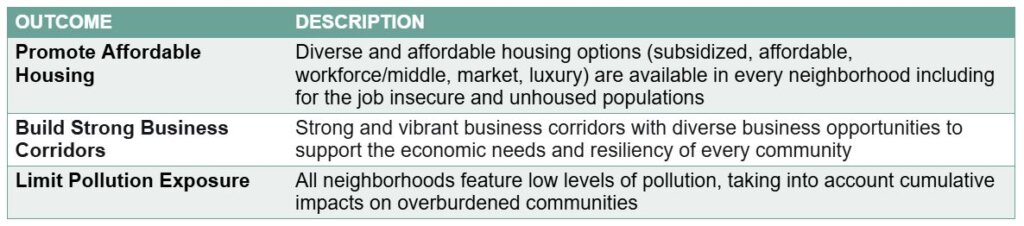
Throughout 2024, we turned our attention to three topic areas that were identified as priorities by the stakeholders we’ve collaborated with or talked to about this work—so far about 200 in total. We completed research to understand how zoning and land use are impacting Chicago’s ability to promote affordable housing, build strong business corridors, and limit pollution exposure. Right now, we are gearing up to share the research findings more broadly to build a base of understanding for change and start discussing how improvements to land use and zoning can benefit the entire city. Through a series of blog posts in March, April, and May, MPC will dive deeper into each one of these topic areas, but first we wanted to start with sharing our research approach and providing some initial highlights of what we found looking through the data.
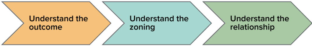
Three-part research approach
Our research focused first on understanding the outcome we were reviewing. For example, for something like affordable housing, we wanted to get a sense of what the overall housing situation looks like in Chicago and provide some overall description of how affordability is defined and where affordable housing is located. Second, we wanted to understand the overall zoning in the city that defines that outcome. If we stick with the housing example, we reviewed where the zoning map says housing can go and what the zoning ordinance says about what the requirements are for that housing. Third, we tried to connect it all together and understand the relationship between the two—to ultimately answer the question of how zoning is impacting affordable housing. The team repeated the same basic analysis, with slightly different questions, to also look at zoning and land use impacts on business corridors and pollution exposure.
We grounded the research in definitions co-created by this initiative’s stakeholders, to determine the type of data and metrics needed for the analysis.
Highlights from our initial findings
After all that data gathering, review, and analysis, here is a key finding for each one of the three outcome areas posed as a series of questions we are answering:
- How affordable is the city of Chicago?
The ability to buy a home has worsened over time, particularly for BIPOC families. The median white family has gained purchasing power, while it has decreased for Latinx, Black, and Asian families since 2000. Overall, there remains greater affordability on the South and Southwest sides of the city. The North and Northwest sides are generally unaffordable for a typical Chicago household. - How do business activity and jobs differ across places?
Areas with higher levels of business activity typically had higher home values, rental rates, and populations, particularly white population. Employment density followed similar patterns. Vacancy rates are greater in lower-income neighborhoods, with majority Black census tracts experiencing vacancy rates double the citywide average. - Which places and people experience pollution exposure?
Latinx populations are exposed to more overall pollution and more air pollution. Across the census tracts with the highest cumulative pollution levels, 37% of the population is Latinx, compared to about 30% of the total citywide population. Latinx populations are also exposed to more pollution in the air specifically: 50% of the population in the highest air pollution census tracts are Latinx.
Stay informed
Want to learn more and find out how zoning and land use are a part of the story? Read more on specific outcomes in our “Improving Zoning Together” blog series at the links below. If you have any questions about this initiative or its research, please reach out to Debbie Liu, dliu@metroplanning.org to learn more.
Related Reading
Blog Series: Improving Zoning Together
- Improving Zoning Together: Introductory Blog
- Limited Pollution Exposure Outcome (Part 1 of 2)
- Limited Pollution Exposure Outcome (Part 2 of 2)
- Affordable Housing Outcome (Part 1 of 2)
- Affordable Housing Outcome (Part 2 of 2)
- Strong Business Corridors Outcome
- Accessible Public Transit Hubs Outcome
- Available Groceries and Healthcare Outcome
- Mitigation and Adaptation to Climate Change Outcome