Improving Zoning Together: Affordable Housing Outcome (Part 2 of 2)

By: Emma Boczek

By: Rachel Gaunce
April 29, 2025 / Blogs
April 29, 2025 / Blogs
Improving Zoning Together: How do zoning and land use affect housing affordability?
Metropolitan Planning Council (MPC) and the Urban Institute are conducting research on how zoning and land use impact Chicago’s neighborhoods and residents from an equity, sustainability, and public health perspective. We are assessing and quantifying the extent to which zoning and changes in zoning have contributed to Chicago’s long-standing inequities across seven priority outcomes: affordable housing, strong business corridors, limited pollution exposure, accessible public transit hubs, productive land use, available groceries and healthcare, and mitigation and adaptation to climate change.
This is the second of a two-part work on affordable housing. This two-part work is part of a larger blog series titled ‘Improving Zoning Together‘, which explores our research findings based on each of the research outcomes.
In our previous blog, our partners Yonah Freemark and Lydia Lo at the Urban Institute helped answer the question: What is the current state of affordable housing in Chicago, and how has it changed over time?
In this blog, we turn to zoning, sharing Urban’s findings on the question: How does zoning shape housing in Chicago, and how does downzoning impact neighborhoods?
Before we go into more detail about the research, the high-level takeaways from Urban’s findings are:
- Chicago’s zoning code limits the amount of new housing that can be legally built in the city. 41 percent of Chicago is zoned for single family homes or two-flats only, while just 11 percent of the city is zoned for three and four-flats and apartment buildings. This restrictive zoning policy leaves very little room to build new housing in large swaths of the city, most notably on the North, Northwest, and far South and Southwest sides. Most community areas in Chicago (58 percent) built fewer than 500 new homes since 2006. The majority (60 percent) of all new homes in the city built since 2006 were concentrated in just five community areas near and in the Loop.
- It is illegal to build new multi-family housing in much of the city without a zoning change. Most new multi-family units are being built as Planned Developments. Planned Developments (PDs) offer more flexibility than traditional zoning districts and include an added layer of public review. From 2006 to 2024, nearly 60 percent of new homes—and over two-thirds of homes in buildings with five or more units—were built as part of a PD.
- Downzonings and historic preservation create more exclusionary neighborhoods. In the decades since 1970, City Council tended to downzone areas that were whiter with higher housing values. After the downzonings, housing construction was limited in those areas, which became even whiter and had even higher housing value increases than areas that were not downzoned.
How does zoning shape housing in Chicago?
To start to understand how zoning intersects with housing affordability in Chicago, Urban looked at the kind of residential construction that the current zoning code allows. Currently, 41 percent of the city is zoned for single-family homes or two-flats only, which tends to be the most expensive kind of housing. Just 11 percent of Chicago is zoned to allow for three and four-flats and apartment buildings—housing types that are typically less expensive than single family homes.
This restrictive zoning limits the amount of room in the city to build more housing. As shown in Figure 1, many parts of the North and Northwest sides, as well as the far South and Southwest sides are almost completely built out based on current zoning laws, meaning it is illegal to build any additional housing there without a zoning change. In contrast, areas like downtown, the West side, and the near South side have more space for development. The areas with less room for new housing tend to be wealthier and whiter than areas with more space for new homes.
Figure 1
What share of housing capacity is now used across the city?
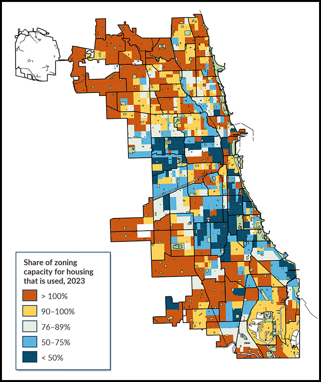
Created by Urban Institute. Source: Chicago zoning 2023
Partially due to the limited space for new housing, Urban Institute found that (as shown in Figure 2) new housing tends to be geographically concentrated: 60 percent of the 121,601 new homes permitted for construction between 2006 and 2024 were concentrated in just five community areas: The near North side, near West side, the Loop, West Town, and the near South Side. Most other communities in Chicago added fewer than 500 new homes in the same time span.
New multi-family housing is typically built through Planned Developments (PDs), where uses may follow the existing zoning, but there is more flexibility than traditional zoning change processes and an added layer of public review. The zoning ordinance requires developments that exceed height, size, and number of unit thresholds to go through the PD process. This requirement applies to most new apartment buildings with more than 50 units. (Some developers also voluntarily opt into the PD process if their development already requires a zoning change.) From 2006 to 2024, nearly 60 percent of new homes—and over two-thirds of homes in buildings with five or more units—were built as part of a PD. Because it is illegal to build residential buildings with more than two units in so much of the city without a zoning change, developers are required—or in some cases are voluntarily choosing—to go through the PD process to build most new multi-family housing.
Figure 2
Permits for new housing, by project unit count, 2006–2024
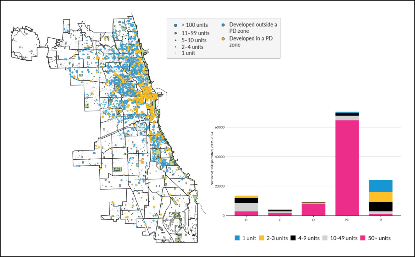
Created by Urban Institute. Source: Building permit data, City of Chicago
How does downzoning impact neighborhoods?
MPC acknowledges that Urban Institute’s research in the following section builds on and supports the downzoning analysis originally included in the report “A City Fragmented: How Race, Power, and Aldermanic Prerogative Shape Chicago’s Neighborhoods.” This report was created by the Chicago Area Fair Housing Alliance in partnership with the Shriver Center on Poverty Law and directly links downzoning with the reduction of affordable housing and multifamily development in Chicago.
Another lens Urban used to investigate the intersection between zoning and housing affordability is Chicago’s history of downzonings. By decreasing allowable residential density—making it possible to build fewer homes in an area—downzonings are a key mechanism through which zoning could potentially impact affordability. Chicago has a long history of alderpeople downzoning and classifying areas for historic preservation, which can also limit residential density. (An important note on terminology: Because our dataset combined them, in this blog post we use “downzoning” to refer to instances of both downzoning and historic preservation.) Based on research from other cities, we can hypothesize that racial and class motivations also played a factor in many downzonings—but does that play out in the data?
The first step to understanding downzonings was to map them. Figure 3 shows downzonings between the 1970s and 2010s, color coded by decade. Downzoning has not been limited to a single area of the city, but consistently across decades, there was frequent downzoning along the lakefront on the North side.
- In the 2000s, downzoning continued on the north side. Residential areas surrounding Humboldt Park were almost entirely downzoned. Parts of Logan Square, particularly along the boulevards, and East Village in West Town were landmarked for historic preservation. Gold Coast, Jackson Park, East Hyde Park, and Woodlawn all experienced downzoning, while Jackson Park Highlands to the south was landmarked.
- In the 1970s, there was substantial downzoning and landmarking in pockets along the north and south lakefront—primarily along Sheridan in Lakeview and along Clark in Lincoln Park, Old Town, and Gold Coast, as well as in Bronzeville and Kenwood. Easy Albany Park and Auburn Gresham also had notable downzoning.
- In the 1980s, downzoning was still mostly concentrated in a few neighborhoods. Almost the entirety of Uptown was downzoned. Other notable downzonings included Edgewater east of Broadway, Park West in Lincoln Park, and parts of Beverly along Longwood Drive.
- In the 1990s, downzoning on the northern lakefront expanded into pockets of Rogers Park and Ravenswood. West Town, Wicker Park, West Loop and Little Italy also had substantial downzoning. There was more downzoning in Kenwood, Pullman, South Chicago, East Chatham, and Armour Square.
Figure 3
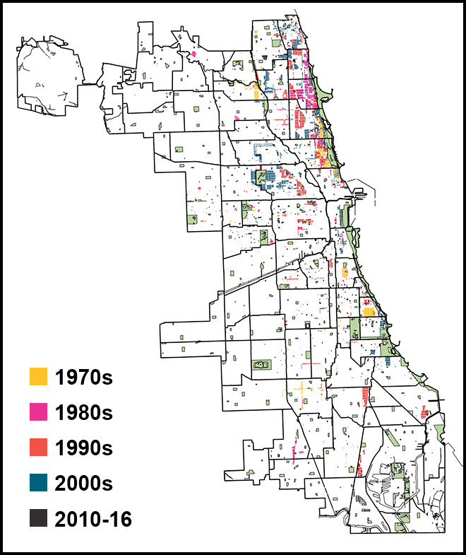
Created by Urban Institute.
Source: Data compiled by George Kisiel of Okrent Associates; measures parcels that were downzoned for each decade from 1970 to 2016.
The next step was to see what patterns emerged in the types of neighborhoods where City Council did significant downzoning. Urban defined “significant” downzoning as at least 10% of a census tract’s land area being downzoned over the course of a decade. They found that downzoning was more common in certain tracts: those with higher median home values and rental costs; higher shares of white population and lower shares of Black population; higher household incomes; and lower shares of homeowners.
Finally, Urban looked at the impacts of downzoning on neighborhoods—how did these significantly downzoned neighborhoods differ from those that weren’t downzoned? Using a fixed effects regression analysis, they found that generally, significant downzoning was associated with less housing construction, a whiter population, and higher median home values over time, though it was not associated with higher rents in this analysis. Urban’s analysis implies that City Council’s downzonings have functioned to create more exclusionary neighborhoods: downzoning was targeted to whiter, higher home value areas, limiting housing construction in those areas, making them whiter and less affordable for homebuyers over time.
Why does this research matter? Our findings confirm that when it comes to new housing development, the status quo of zoning in Chicago is not resulting in equitable outcomes. Especially given the affordability challenges faced by Chicagoans, every neighborhood—not just a select few—needs plenty of options for housing to meet the needs of all neighbors.
This research matters because the cost of housing impacts everyone, representing most households’ largest monthly expense. According to the National Low-Income Housing Coalition, there is a need for about 230,000 additional affordable rental homes for very low-income renter households in the Chicago metro area. Our findings confirm that when housing becomes less affordable, the consequences fall on certain communities more than others, primarily Black and Latinx Chicagoans. Making Chicago a welcoming, thriving place to live requires using all the tools we have—zoning included—to ensure that everyone has an affordable place to live.
This blog is part two of two exploring research findings for the affordable housing outcome. Part one focuses on the current state of affordable housing in Chicago, and how has it changed over time. These blogs are part of the larger “Improving Zoning Together” series which analyzes data on the effects of land use and zoning on the outcomes of limited pollution exposure, affordable housing, and strong business corridors. Overall, the goal of this research is to first inform and then to make changes. If we find that zoning is having an inequitable, unsustainable, unhealthy impact on residents and communities, we can collaboratively advance needed reforms to change this.
For more information about the affordable housing research, reach out to Rachel Gaunce (rgaunce@metroplanning.org) and Emma Boczek (eboczek@metroplanning.org).
Related Reading
Blog Series: Improving Zoning Together
- Improving Zoning Together: Introductory Blog
- Limited Pollution Exposure Outcome (Part 1 of 2)
- Limited Pollution Exposure Outcome (Part 2 of 2)
- Affordable Housing Outcome (Part 1 of 2)
- Affordable Housing Outcome (Part 2 of 2)
- Strong Business Corridors Outcome
- Accessible Public Transit Hubs Outcome
- Available Groceries and Healthcare Outcome
- Mitigation and Adaptation to Climate Change Outcome