Improving Zoning Together: Accessible Public Transit Hubs Outcome

By: Rachel Gaunce
January 22, 2026 / Blogs
January 22, 2026 / Blogs
Improving Zoning Together: How do zoning and land use affect access to transit in Chicago?
Metropolitan Planning Council (MPC) and the Urban Institute are conducting research on how zoning and land use impact Chicago’s neighborhoods and residents from an equity, sustainability, and public health perspective. We are assessing and quantifying the extent to which zoning and changes in zoning have contributed to Chicago’s long-standing inequities across seven priority outcomes: affordable housing, strong business corridors, limited pollution exposure, accessible public transit hubs, productive land use, available groceries and healthcare, and mitigation and adaptation to climate change.
This work on accessible public transit hubs is part of a larger blog series titled ‘Improving Zoning Together‘, which explores our research findings based on each of the research outcomes.
In this blog, MPC provides a summary of findings from our research partner Yonah Freemark at the Urban Institute, covering what the data shows about 1) the landscape of transit access in Chicago, 2) how current zoning impacts what gets developed near transit, and 3) the relationship between zoning districts and transit access.
Which places and people have access to transit in Chicago, and how are the areas nearest to transit changing over time?
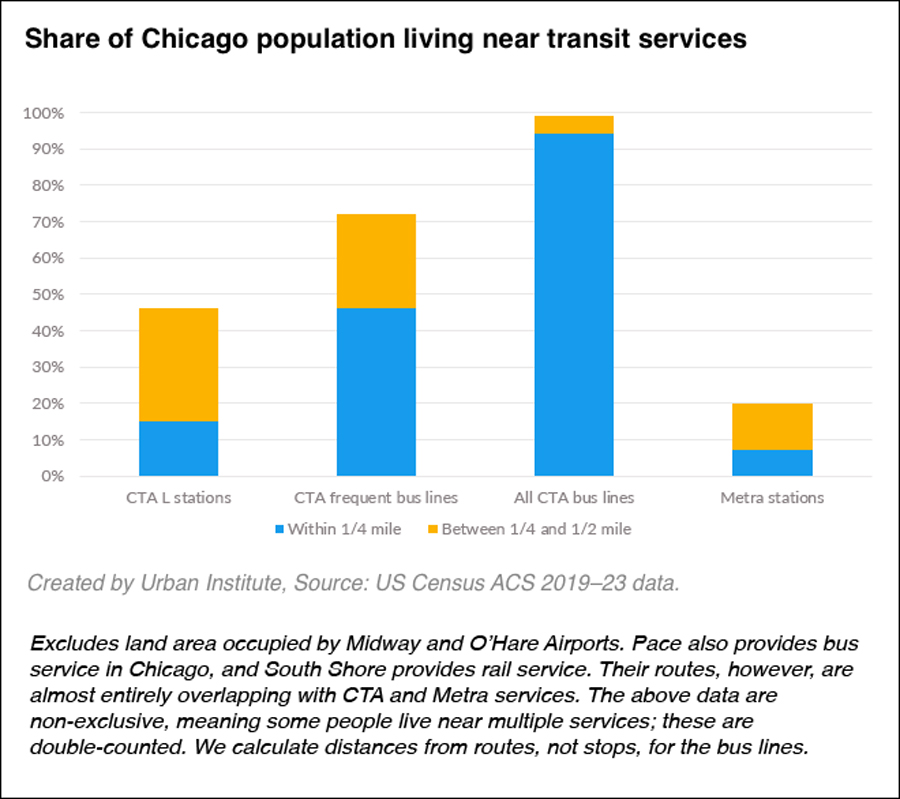
Nearly all Chicago residents (95%) live within a quarter mile of a CTA bus line—at this distance, most pedestrians can walk or roll to access the bus within 5 minutes—but access is more limited for rapid transit. Only about 15% of residents live within a quarter mile of ‘L’ train stations and about 45% live within a quarter mile of CTA’s frequent bus network (Figure 1).
Figure 1
Between 2005 and 2023, areas within half a mile of train stations, especially the ‘L,’ retained more population than areas further away. However, population change varied widely by geography (Figure 2) and racial and ethnic group (Figure 3). The Central planning region of Chicago (encompassing the Loop and the surrounding neighborhoods), has robust access to transit stations. This area experienced the largest population growth, both in transit areas and elsewhere. The Southwest planning region, which includes communities around ‘L’ stations in Bridgeport, McKinley Park, Brighton Park, and Archer Heights, experienced the greatest percentage population loss near rail transit stations.
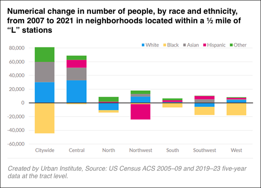
At the same time, there was a decline in the number of Black residents near rail transit stations across the city. The Latinx population remained relatively stable near stations, though there was a large decrease in Latinx population near transit on the Northwest side, which includes communities along the ‘L’ in Logan Square, Avondale, Irving Park, and Jefferson Park.
Living near transit has become more expensive over time in Chicago: changes in the cost of rent and household incomes also varied by geographic area, but tended to grow more quickly near ‘L’ and Metra stations than elsewhere.
Figure 2
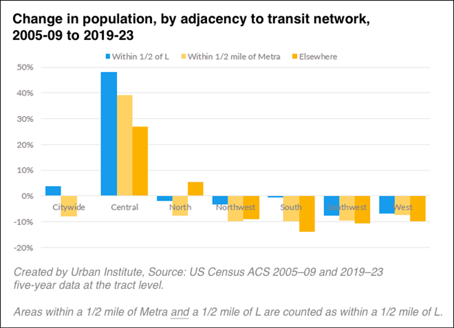
Figure 3
How is Chicago’s zoning policy related to development near transit?
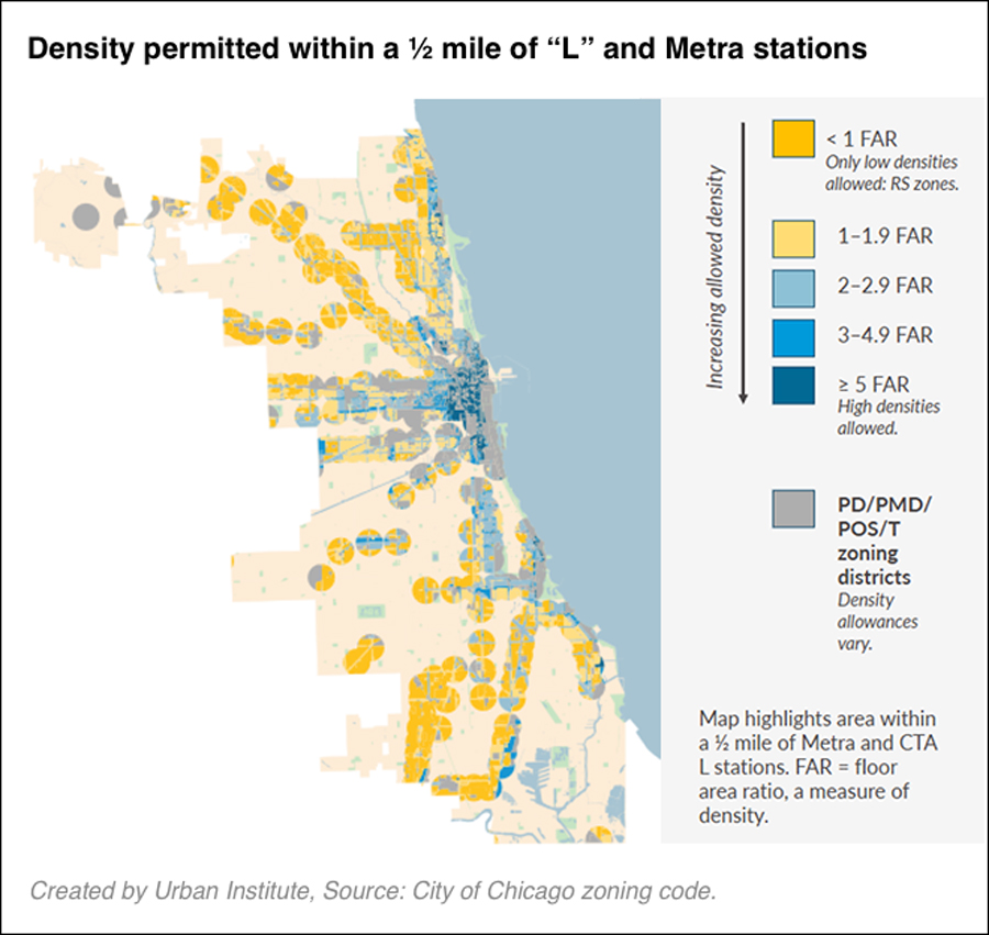
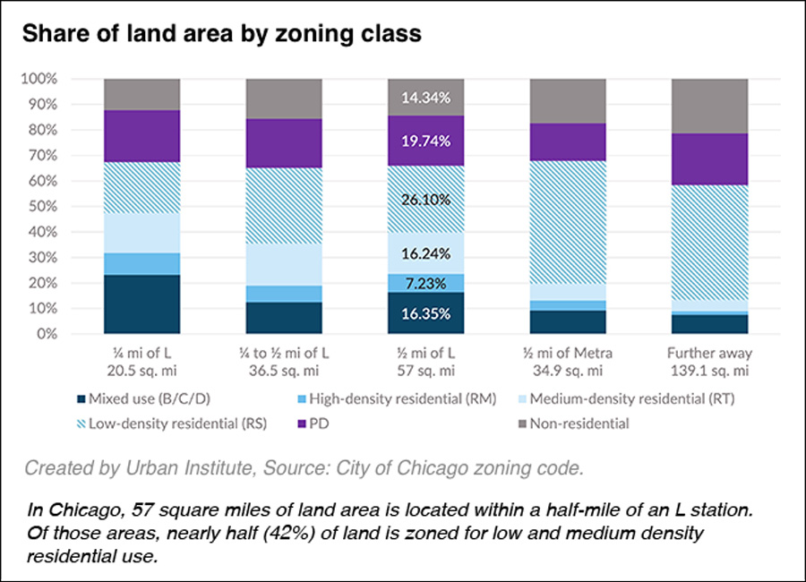
Chicago’s zoning code prohibits higher densities near transit in much of the city. High densities near transit are allowed almost exclusively downtown and east of the Red Line corridor (Figure 4). Indeed, within a half-mile of many rail transit stations, very low density, single-use zoning, such as regulations preventing the construction of all but one- or two-family homes, remains common—even along some of the city’s most used transit corridors, like the north Blue and Brown Lines.
Figure 4
What does the data tell us about the relationship between zoning and transit access?
Mixed-use and high-density zoning are both more common within a half-mile of transit stations than further away. Nevertheless, most land near ‘L’ and Metra stations is zoned for low density residential use. This policy limits how many people can live near transit stations.
Figure 5
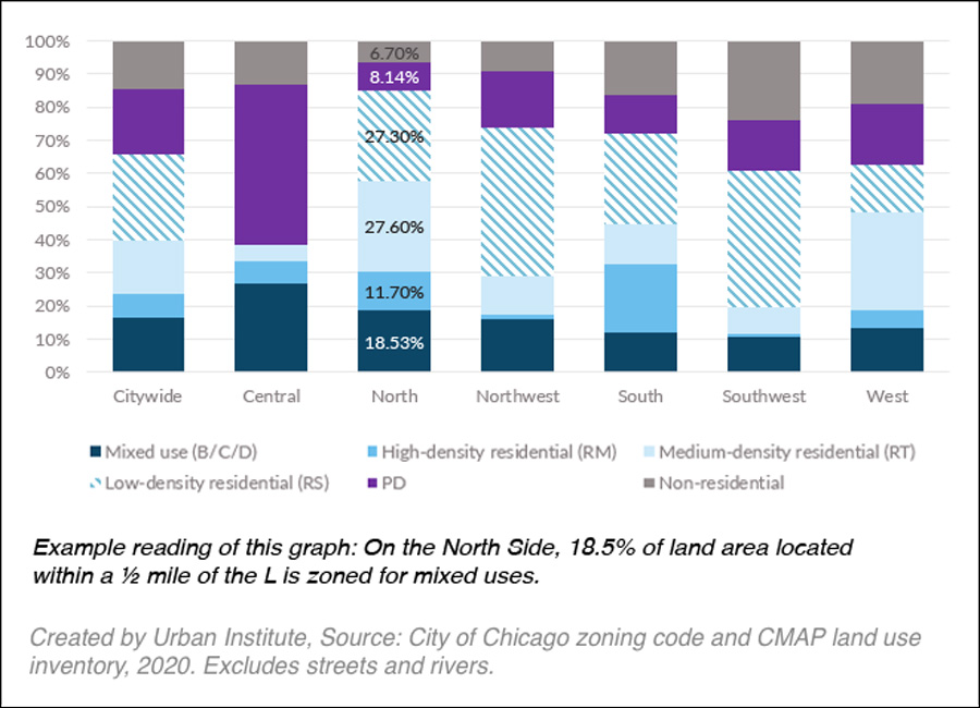
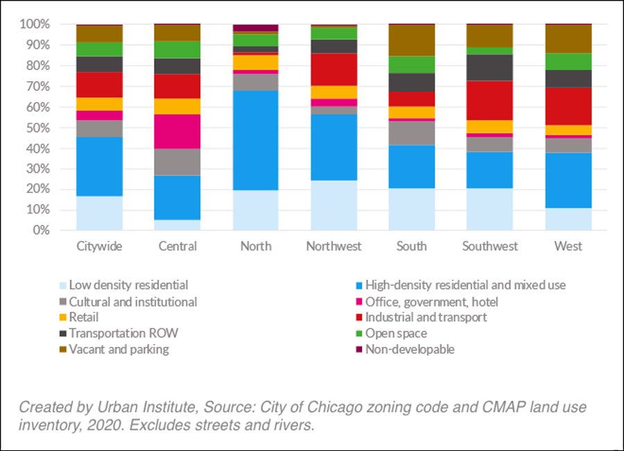
Zoning dictates the kind of development that can be built in the future, but doesn’t always represent current land use, because zoning changes over time. Low density, single family development is a much smaller proportion of the land area near the ‘L’ than the share of land area that is now zoned for low density residential development, indicating there is a mismatch between what the zoning code allows and the land-use patterns of the neighborhoods people actually inhabit. For example, in Figure 6 in the chart on the left, 27 percent of the North side is zoned for low density residential, but looking at the chart on the right, less than 20 percent of the actual land use in the North side is low density residential.
Figure 6
Share of land area by zoning class compared to land use within ½ mile of “L” stations
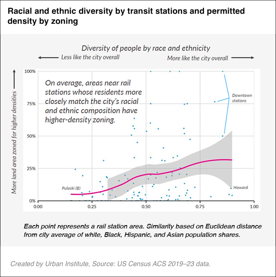
This research suggests that high density zoning near transit is linked with higher levels of racial diversity. On average, higher-density zoning near transit is more common in areas with racial diversity that matches the city (Figure 7).
Figure 7
Looking toward future transit access in Chicago
Chicago’s transit network is a major asset, but Urban Institute’s research shows the benefits of transit are unevenly realized. While many Chicagoans live close to bus routes, access to rapid transit remains limited to a minority of residents, and trends in population, incomes, and housing costs show that neighborhoods near stations are changing in unequal ways. Zoning rules limit the opportunity for residents to have access to high-quality rapid transit by restricting development to largely low-density housing.
Expanding opportunities for Chicagoans to affordably live, work, and recreate near transit is even more important after the passage of the Northern Illinois Transit Authority Act (NITA) in Springfield in the fall of 2025, which included transit governance reforms. NITA increased the annual operating budget for transit in Northern Illinois by $1.5 billion per year. With the law’s enactment, our transit system will offer more frequent, reliable service that should be accessible to all Chicagoans. MPC and our partners are continuing to develop recommendations to shape land use and zoning policies that expand access to transit in Chicago.
Related Reading
Blog Series: Improving Zoning Together
- Improving Zoning Together: Introductory Blog
- Limited Pollution Exposure Outcome (Part 1 of 2)
- Limited Pollution Exposure Outcome (Part 2 of 2)
- Affordable Housing Outcome (Part 1 of 2)
- Affordable Housing Outcome (Part 2 of 2)
- Strong Business Corridors Outcome
- Accessible Public Transit Hubs Outcome
- Available Groceries and Healthcare Outcome
- Mitigation and Adaptation to Climate Change Outcome