Zoning & Land Use Assessment
Creating a shared understanding and recommendations to promote equity, sustainability, and public health for Chicago’s land use and zoning
Every neighborhood should provide residents with opportunities to thrive. This requires quality jobs and access to transit, parks, affordable housing, retail, and entertainment that influence the wellbeing of all individuals. Nationwide and across Chicago, not everyone has the same access to opportunity and resources. Zoning and land use are policy and planning tools that can help shape the way that residents interact with their neighborhoods and lead to greater equitable and sustainable development.
Why do zoning and land use matter?
Zoning and land use help define how residents experience their neighborhoods. They impact the availability of public services, transportation, employment, and housing for renters and homeowners–and ultimately impact all Chicagoans health, wellness, and quality of life. Because zoning and land use in Chicago can often seem invisible to residents or is a process that people do not routinely interact with, it can be overlooked.
Zoning and land use impact both big and small quality of life measures, determining whether you can have a park in your neighborhood, if a new small business owner can open a bakery, if there is too much parking or not enough, how you can build your mother-in-law an apartment above your garage, or whether the vacant lot on your block can become a grocery store, a new residential building, a gas station, or a factory.
These big and small zoning and land use decisions all add up to change the feel and experience of your neighborhood and influence the opportunities available to you locally. Right now, we do not know the overall effect that zoning and land use are having at the city or neighborhood level, but we want to. That’s why MPC and the Urban Institute are developing a collaborative assessment to determine their health, equity, and sustainability impacts.
Assessment & Research
Evidence-based and collaborative policy recommendations
Zoning and land use are key tools with the ability to produce more equitable, healthy, and resilient communities. This participatory research will lay the groundwork for reform.
The Project
In collaboration with stakeholders, MPC and the Urban Institute are leading a new initiative designed to target changes in Chicago zoning that can advance more equitable, livable communities. Through this project, we will assess the City of Chicago’s zoning and land use practices and process to develop a shared understanding of the equity, sustainability and health impacts on its residents and communities. We will evaluate and identify problems with the current zoning code, and recommend revisions that could be applied citywide. The goal is to set a baseline so that we all understand how we can make changes that equitably benefit Chicago’s communities.
Project Phases
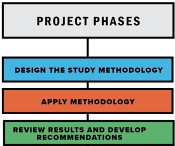
This project spans multiple years across three phases. The project’s Steering Committee is guiding the work of the assessment, and the project team is collaborating with civic and community partners throughout all the phases. The Zoning Assessment is currently in Phase III. In this phase, the project team is reviewing research with input from the project’s advisors and developing policy recommendations. The project team also launched a resource, with the support of our Community Advisory Group to help community groups and residents understand and navigate zoning in Chicago. Find more information on the activities completed in Phase 1 and the research findings as part of Phase 2.
Stakeholder Collaboration
The project’s Steering Committee includes a mix of different stakeholders including people from government, civic, community, private, and academic sectors. The project team also hosted focus groups with civic and community organizations to learn their perspectives on and experiences with development, land use, and zoning. Finally, the project’s Community Advisory Group brings together representatives from civic and neighborhood groups to support the creation of a zoning resource for residents and community groups.
Learn more about these components of stakeholder engagement below.
- Steering Committee Members (Phase 1)
- Steering Committee Members (Phase 2)
- Steering Committee Meetings
- Focus Group Participation
- Community Advisory Group Participants
- Community Advisory Group Meetings
Zoning Basics
Zoning 101
Zoning has existed in the United States for nearly a century, when the power for municipalities to enact zoning regulations was upheld by the Supreme Court in the 1926 Euclid decision. Zoning today is a regulatory tool that cities use to control the types of land uses allowed in specific areas. It also designates the volume, height, shape, location, and parking requirements of buildings that make up the neighborhoods around us.
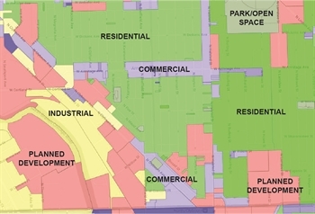
Zoning typically divides a city into zoning districts. These districts are grouped into broad categories like Residential, Commercial, Manufacturing, and Transportation. Zoning districts are described in the zoning ordinance and shown on the zoning map. The zoning ordinance (or code) is essentially a set of instructions that says what is allowed in each district. The zoning map is how the ordinance spatially applies to each city. This diagram represents how multiple types of zoning and land uses can exist next to each other and shows some of the major categories that are part of the neighborhood fabric.
Chicago Zoning
History of Chicago Zoning
The first zoning code was enacted in Chicago in 1923. Codes are technically ‘race neutral’ in how they are written, but the first Chicago zoning code, much like zoning in other cities, was created at a time when zoning was viewed as a policy mechanism to not just separate types of buildings, but also create and maintain segregation for types of people by race, immigration status, and income. Research has shown that the racial makeup of existing communities was a key factor in locating future developments of increased density and industrial uses. To learn more about how different groups of residents have been burdened or have benefitted from zoning changes, including the creation of the code, check out these Historical Acknowledgement Case Studies.
Since the first zoning code was enacted in Chicago, the code has been rewritten three times and undergone numerous smaller changes and additions. Some of the changes have included updates to parking requirements, new ‘special districts’ and add on ordinances for Lakefront Protection, Air Quality, and Affordable Housing Requirements. Find out more about the history of zoning in Chicago and these changes in our Detailed Zoning Timeline.
Current Chicago Zoning
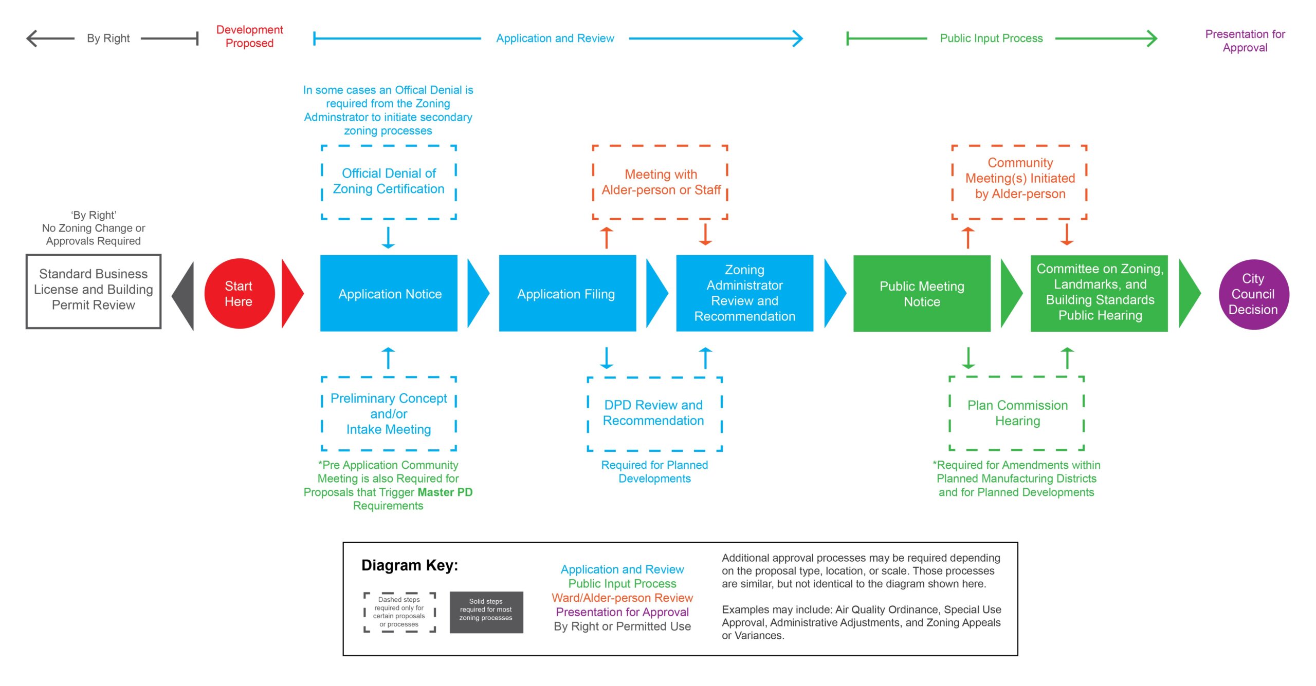
Zoning can be challenging to understand. There are many different types of zoning processes in Chicago, influencing how development is done in the city. Zoning interacts with the development process when people want to build things and/or change uses in certain areas. Developments can be built based on what the existing code and map say is allowed in an area. These developments are called ‘by right.’ If a development requires a different type of use or wants a different density, then it will need to request a change to its zoning, typically to its map designation, although zoning changes can take other forms like a zoning variance, defined with other relevant zoning terms in our Glossary of Zoning Terms.
Depending on the type of development and zoning change, additional community meetings and city approvals could be required. There are approximately 12 different processes to follow for developments related to zoning, and we illustrated them. Here are some diagrams If you want to get into the weeds on Chicago’s Zoning Process, which includes flow charts for all the processes. If you want to keep it high-level, we also have a Simplified Zoning Process Diagram that combines all the processes into one general chart with offshoots depending on the type of zoning change that is needed.
There are also a number of other regulations and standards that may influence the zoning and development process for a project. To understand more about the additional requirements, like the Building Code or the Sustainable Development Policy, read through our Zoning Processes and Additional Regulations document.
To find out more about zoning and what type of zoning you have in your community visit 2nd City Zoning or the Official Chicago Zoning and Land Use Map.