Taking Climate Action by Biking and Walking

By: Audrey Wennink
May 16, 2022 / Blogs
May 16, 2022 / Blogs
First in a Series of Events by the Metropolitan Planning Council, Metropolitan Mayors Caucus, and Active Transportation Alliance
A key strategy in the Metropolitan Mayors Caucus (MMC) regional Climate Action Plan is reducing the amount of driving in our region to curb climate-busting emissions. In a webinar event April 28, Chairman of the MMC’s Environment Committee, Geneva Mayor Kevin Burns, highlighted how local communities can take action on climate change by supporting biking, walking, and using transit. Strategies include building and maintaining safe, resilient, and accessible active transportation infrastructure, and fostering a community culture of getting around via biking, walking, and using transit.
Read on for a recap of the event, which is available as a recording here.
Why develop a bicycle and pedestrian plan?
The panel of speakers included Active Transportation Alliance Advocacy Manager Maggie Czerwinski, Richton Park Village Manager Ryan Stockstell, and Niles Planner Nathan Bruemmer, with discussion moderated by Metropolitan Planning Council Transportation Director Audrey Wennink. Panelists discussed the important role bike and pedestrian plans play in achieving not only the climate benefits of walking and biking, but broader benefits as well. “Development of an active transportation plan creates an opportunity for residents to get engaged in what they want the community to look like in the future in terms of creating a complete, accessible transportation network,” said Maggie Czerwinski.
A community that invests in walking and biking can achieve many benefits with careful planning, including a cleaner environment, vibrant local economy, healthier lifestyles, increased traffic safety, improved social cohesion, enhanced mental wellbeing, greater access to nature, and a reduction in greenhouse gas emissions.
Having a plan also helps communities know which projects to tackle first, and positions communities as ready to receive grants funds that may be necessary to get the job done.
By developing a plan, a community also develops consensus on how to spend its local transportation funds. General transportation funds that come to a community via its property taxes or the state motor fuel tax are very flexible and can be used for bicycle and pedestrian investments. Having a plan also helps communities know which projects to tackle first, and positions communities as ready to receive grant funds that may be necessary to get the job done.
Community examples
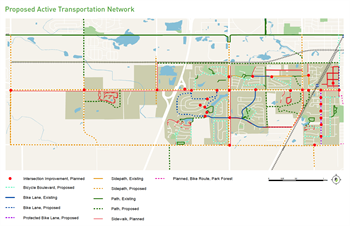
At the event, Richton Park Village Manager Ryan Stockstell and Niles Planner Nathan Bruemmer detailed the process of developing and implementing their active transportation plans. For Richton Park, the first step was to establish a Complete Streets policy in 2016. To socialize the importance of slowing traffic to improve safety for biking and walking, Richton Park developed a pop-up traffic calming Complete Streets event. Soon after, the community was able to secure resources to develop an Active Transportation Plan with help from the Active Transportation Alliance. The plan identifies a range of projects and recommends phasing, as shown in the map below.
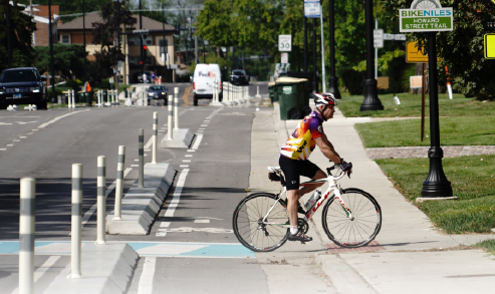
In 2014, Niles adopted its first active transportation plan, which is currently being updated. The initial plan’s goals were mobility and access, amenity, culture, and turning Milwaukee Avenue into a walkable and transit-friendly environment in anticipation of Pace initiating Pulse arterial rapid transit bus service along Milwaukee Road in Niles. When Niles started developing the first plan, the village had no on-street bike facilities. The only major facility was the North Branch Trail in the Cook County Forest Preserve. The 2014 plan recommended 13 miles of new bike facilities. So far one-third of the 2014 plan’s recommendations have been implemented, with the most significant installation being protected bike lanes and a shared-use path along Howard Street.
Niles residents and village officials confronted the important role of bike and pedestrian planning in July 2020, when a 13-year-old boy was fatally hit by a car when trying to cross Waukegan Road on his bike. The village formed a Bicycle and Pedestrian Advisory Group. With this very engaged group, village staff decided to update the bike plan. The new plan builds on the 2014 plan, recommending more than 18 miles of new sidewalks, 6.7 miles of shared-use paths, 10.4 miles of on-street bicycle facilities, and a number of intersection improvements.
In 2021, the Village completed 3,200 feet of protected bike lanes as part of a “road diet” project from Waukegan Road to Caldwell Avenue Niles also installed 4,200 feet of off-road side paths from Caldwell to Lehigh. The project has achieved numerous benefits, including the following:
- Average reduction of total vehicle traffic by 21 percent
- Average reduction of total semi-truck traffic by 47 percent in area with road diet
- Improved intersection level of service, reduced queue lengths
- Increased average pedestrian and bicycle counts along corridor
- 234 pedestrians and 976 cyclists used improved North Branch Trail crossing at Howard Street on the day of the usage count
Lessons Learned
During the question-and-answer portion of the event, panelists shared their experiences on the ground, which included the fact that roadway ownership can be a significant dimension of planning. A municipality usually does not own all the roads in its jurisdiction and may have to work closely with the Illinois Department of Transportation (IDOT) or a county DOT to make changes on roads they own within the community. Strong partnerships with overlapping transportation agencies are often critical to effective planning. Also, it can be challenging to secure engagement from a broad range of residents, but it’s worth the effort to secure community buy-in and ensure any individual perspective does not overshadow a more comprehensive view of needs.
For Richton Park, the biggest benefit of developing an active transportation plan has been having a roadmap of what to do next so it’s easier to pursue funding since the case has been made for why a project is needed. Nathan Bruemmer of Niles noted that when you are managing the entire roadway network, every time you need to maintain a street, you can incorporate the bicycle and pedestrian upgrades from the active transportation plan into the roadway project.
“A great benefit is that a plan signifies that Niles is committed to being a healthy community, which will hopefully make it a desirable place to live for new residents.” –Nathan Bruemmer, Niles
A participant at the event asked if a complete list of communities in northeastern Illinois with active transportation plans exists, so neighboring municipalities can work together on network-scale planning. Audrey Wennink of MPC noted that part of the collaborative effort between MPC, MMC and ATA is developing a database documenting and linking to every active transportation plan in the region. This resource should be complete by the end of 2022 and a link to the online dataset will be made available by the three organizations.
Key funding sources discussed include the Illinois Department of Transportation’s Illinois Transportation Enhancement Program, the Invest in Cook program, federal Surface Transportation Program Block Grant funds that are disbursed via the Chicago Metropolitan Agency for Planning (CMAP) shared fund and the regional Councils of Mayors (local programs), and federal funds distributed via CMAP through the Congestion Mitigation and Air Quality Program (CMAQ) and the Transportation Alternatives Program (TAP).
Four additional events in the series will be held during 2022 – check the event website for updates:
- A virtual roundtable on transit-oriented development in our region – June 22, 2022
- A webinar on how to apply for active transportation funding – July 14, 2022
- A walking tour of a community implementing its active transportation plan — August 12, 2022
- A virtual panel on ADA transition planning – October 2022