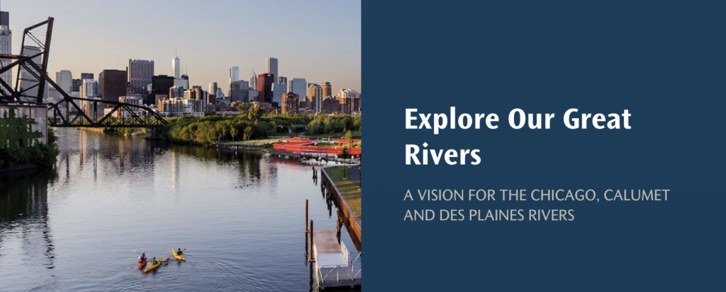
Explore Our Great Rivers Story Map
We’re in the middle of a renaissance of sorts along Chicago’s waterways. The catch? Most people aren’t familiar with the ground-breaking, community-centered, nationally-significant work that’s been happening in recent years.
That’s why MPC launched an interactive story map, Explore Our Great Rivers, in August 2021. This map highlights community activation projects funded through The Chicago Community Trust’s Our Great Rivers grant. The focus of these projects include community planning, research, advocacy, arts and culture, and more. In-depth stories about each project can be found on MPC’s blog.
Here’s a peek at the interactive map:
Exploring Our Great Rivers
An event launched the story map to the public in August 2021
On August 25, 2021, MPC held an event to launch the Explore Our Great Rivers story map and showcase other rivers partners who are also using story maps and visual tools to connect Chicagoans with our rivers.
The event opened with a land acknowledgement by Chloe Gurin-Sands, Manager of Equity & Planning at MPC. Chloe also provided background on Our Great Rivers: A Community Vision to Make the Des Plaines, Calumet and Chicago Rivers More Inviting, Living and Productive, released in 2016 by the City of Chicago, Metropolitan Planning Council, Chicago Metropolitan Agency for Planning, and Friends of the Chicago River. This engagement process included input and feedback from more than 6,000 residents and has brought over $1.5 million in riverfront investments.
Opening remarks were followed by a presentation from the event moderators, Laura Barghusen and Lillian Holden from Openlands, who walked participants through two of Openlands’ story maps created to forge meaningful connections between the community and the Little Calumet River. The African-American Heritage Water Trail showcases the role of the Little Calumet River in African-American history, including the Great Migration and Underground Railroad. The Riverdale Community Assets map was designed to be an interactive tool to highlight community assets such as open space, transportation, and health resources.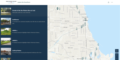 A look at the interactive, online story map
As we moved to the panel portion of the event, Carson Poole, organizer with the North River Commission (NRC), spoke about their project “Confluence.” A core objective of the Confluence project is to develop a series of physical improvements and programming surrounding Ronan Park, located adjacent to the North Branch of the Chicago River in Albany Park. Carson announced the riverfront projects in their service area, including Ronan Park, are set to see $7.5 million worth of improvements through the Chicago Park District with funding received from the City of Chicago. The North River Commission worked with Perkins+Will and Omni Systems as pro-bono partners to develop site plans, renderings and a story map to tell the story of how Confluence came to be. Click here to check out the Confluence story map.
Up next was Alex Perez, Advocacy Manager with Active Transportation Alliance (ATA), to talk about the “Chicago Riverpark” project. The project aims to provide a more comfortable and safer route for pedestrians and cyclists on Upper Wacker Drive by installing a two-way bicycle path from Orleans Street to Columbus Drive. A two-way bicycle path will improve connectivity to Upper Wacker Drive, the Chicago River, and the lake while providing relief from sharing the Riverwalk or sidewalk with pedestrians. The project is still in its initial stages and ATA continues to engage local stakeholders.
To close the program, Chloe Gurin-Sands introduced the Explore Our Great Rivers story map. For four years, MPC has been providing technical and advocacy support while has been publishing blog posts and reports detailing the progress each project is making. After the success of our Great Rivers Chicago social media campaigns in 2020 and this year, an idea sprouted—to develop a user-friendly visual tool. Maps are an integral part of storytelling of who and why these projects are happening, and why they are so important to the communities leading them. This led to the creation of the Explore Our Great Rivers story map.
Meet the Explore Our Great Rivers story map
What’s next for Our Great Rivers projects?
MPC is excited about all the work that has happened to date and is looking forward to digging in to this new year of funded projects to continue this momentum and provide resources and support to projects that help grow community wealth, activate their neighborhoods, and support the restoration of local ecologies and natural environments. We heard from three phenomenal rivers projects but there a dozen more projects to learn about. Make sure to explore the story map and get out on the river.