Lens on the Calumet Corridor | The Need for More Community-Centered Land Use Planning for the Calumet Industrial Corridor

By: Christina Harris
January 5, 2022 / Blogs
January 5, 2022 / Blogs
An environmental justice collaborative in Southeast Chicago spent two years studying the lasting health impacts of industry in their community. Lens on the Calumet Corridor: A blog series highlighting the research in the Calumet Connect Data Book captures what they discovered, and why it’s time for a change. This is the sixth blog in our six-part series.
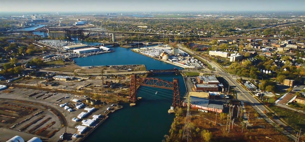
Land use and zoning in Chicago is due for a refresh. In Chicago, zoning regulates the types of uses that occur on parcels of land as well as land use volumes, such as density of development, and height, shape, and placement of buildings. It also determines parking requirements and other development activities. The city’s industrial corridors have a type of designated zoning that allows for uses such as manufacturing and other industries. (1) These areas have evolved over time with many seeing more commercial and residential uses. In 2016 the city started an Industrial Corridor Modernization process, acknowledging that land use designations in industrial corridors needed an update. The process started with the North Branch Industrial Corridor, which was completed in 2017. Now, the Calumet Industrial Corridor is next in line for modernization. As part of creating the Calumet Connect Data Book, the project team did a deep dive into the corridor’s current land uses and zoning to review what’s happening on the ground. Based on this analysis, the team can offer some recommendations to the City for a new approach to thinking about the types of uses permitted in communities where people live, work, and play.
Corridor Land Use Changes
Through the analysis of current land uses, the team discovered that the Calumet Industrial Corridor’s land use and zoning policies do not fully support the Calumet community’s goals for a healthy and environmentally just corridor. In considering any land use and zoning changes, it is critical to acknowledge the corridor’s placement: 1) within an environmental justice community and 2) in close proximity to Lake Calumet, which functions “as a central component of a much larger ecosystem and trail network.”
The team’s review of the most recent land use data (2013) compared with more historical zoning/land use data (1990) revealed that the Calumet Industrial Corridor increased in its viability for industrial transportation and institutional uses. From 1990 to 2013, the study area observed a notable increase in transportation facilities, terminals, and docks, which grew to be the largest land use allocation by share (22.43%) in 2013 (see Table 1, below). In addition, the Calumet remains the only industrial corridor that allows for storage and disposal of hazardous materials by right. (2)
Table 1: Comparison between 1990 and 2013 land uses in the Calumet Industrial Corridor
Land Use* | 1990 | 2013 | |
Transportation/Communication/Utilities/Waste | 25.37% | 40.97% | ↑ |
Vacant/Under Construction | 17.72% | 14.66% | ↓ |
Industrial | 19.06% | 12.39% | ↓ |
Residential | 14.70% | 10.77% | ↓ |
Open Space | 4.85% | 9.82% | ↑ |
Water/Other | 14.53% | 7.49% | ↓ |
Institutional | 1.18% | 2.02% | ↑ |
Commercial | 2.59% | 1.88% | ↓ |
Agriculture | 0 | 0 | |
Total | 100.00% | 100.00% | |
*Note: In this table, ‘Land Use’ represents aggregates of the primary land use code categories. | |||
Note: This table was retrieved from the Calumet Connect Databook, Page 103, Table 15
While conducting the land use analysis, the team identified a limitation in the ability to complete a truly rigorous comparison between 1990 and 2013 land uses, due to a change in methodologies in the source data. (3) Though the team was able to work around most of the technical and information access challenges encountered over the course of this project, it is clear that not all organizations would have the capacity or technical abilities to do so. These data usage challenges have the potential to limit informational access for community advocacy.
Beyond the data limitations presented in retrieving this information, the overall trend of increasing land uses toward transportation is not in line with many residents’ desires to see more commercial and residential uses along with more separation from heavy industry. This, coupled with the data access challenges, often leaves the community feeling left out of the planning process. Through the course of our research, the team heard from community residents about their desire to be more included in land use decisions and processes. They have often felt denied a voice in how the Industrial Corridor changes. As one resident stated,
“It’s hard for me to see the City would do anything for us because they’ve already got plans. And it’s not for us. It’s about us, but it’s not for us. I don’t see it at all. I don’t.”
This lack of meaningful City-led engagement in environmental justice communities means that, often, community organizing and planning occurs absent City involvement. Information access and data usage challenges also highlight the need for community-based planning processes to emphasize translation and clear articulation of the data so that the information is not only held by the City but shared widely with residents so that all parties are entering the conversation together with the same background knowledge.
Proactive, Participatory Planning
One of the biggest challenges of urban planning at large has been inconsistent standards and processes around participatory planning. This is seen not only in revisions to industrial corridor land uses but also whenever any new development project is proposed in the city. The inconsistency makes it incredibly difficult for residents to engage meaningfully. Absent a formal City planning process, residents of the Southeast Side have expressed a desired vision for their community through various forums. This vision includes the revitalization of existing resources (such as parks, art, and small businesses), as well as a need for solutions for planning that accounts for both industry and sustainable, health-promoting decision-making. However, as was made clear through the project’s community needs assessment, residents do not feel acknowledged or heard by the City. Residents have ideas, and they are interested in engaging on equal terms to see if those ideas can be realized. As one study participant noted:
“So before I could tell you what I want, I have to — I have to see what is doable, actually talk to — talk to a planner and just say, you know, “This is what we’re — this is what we’d like to see, you know. What would it take?” And maybe he’d say, “Ah, you’ll never do it.” Well, then I don’t want to talk to you. You’re not a good planner. I want to talk to a planner that is willing to open up and see what our ideas are, you know, because we talk about the — we-we talk about the corridor and everything.”
In order to build prosperous, equitable, and environmentally just spaces that are reflective of a collaborative vision between residents and the City, the planning process needs to be restructured to truly champion and honor the agency of disinvested communities. There are examples throughout the City of community- or civic-led participatory planning processes that have successfully engaged local residents in crafting a vision for their neighborhood’s future. One example is the multi-stakeholder effort of the development of South Chicago’s Commercial Avenue Revitalization Plan (led by UIC Great Cities Institute), which was a planning process that intentionally engaged and shared power with various stakeholders. Another example is being led by Alderman Carlos Ramirez-Rosa in Chicago’s 35th ward. Through a community-driven process, a participatory model was developed to review local requests for zoning changes. Community groups assist with the review process for zoning change applications and make recommendations about how the office responds. If the response is positive, a broader community meeting is held to review the project for additional feedback.
As the Calumet Industrial Corridor Modernization Process officially kicks off it is our hope that the City will incorporate some of the best practices in participatory planning that have been used locally and focus on equity-centered engagement strategies that prioritize entering into dialogue with residents on equal footing, acknowledging community members lived experience and working with the many stakeholders in the Calumet region to draft a people-focused, environmentally sustainable path forward for the industrial corridor.
References
Endnotes
(1) Want to learn more about zoning? Check out some of these resources that have been compiled by the Alliance for the Great Lakes used in their Elevating Justice curriculum: Zoning Video, Zoning Cheat Sheet, Chicago Online Zoning Map, Understand Chicago Zoning, Planned Developments, Planned Manufacturing District Zoning for Calumet.
(2) For more on land use planning and industrial corridors, please review our second blog in this series: Inequitable pollution exposure is rooted in land use planning.
(3) As per the Chicago Metropolitan Agency for Planning’s Land Use Inventory, land use polygons of the 2013 inventory are based on county parcel boundaries, while earlier inventories, such as the 1990 one, are polygon-based.