Advancing Transit- Supportive Development in Chicago-area Suburbs
Co-authored by Audrey Wennink, Hugo Coronado, Thomas Bamonte, Kris Tiongson, and Rachel Gaunce
Transit moves people. And the economy. Many area residents depend on reliable and frequent transit services that connect them to their daily activities effectively and affordably. And even those that don’t use transit themselves benefit from workers like nurses, retail workers and restaurant servers being able to get to their jobs using transit. High quality transit, in turn, depends on certain population and land use patterns discussed below.
Density and Transit
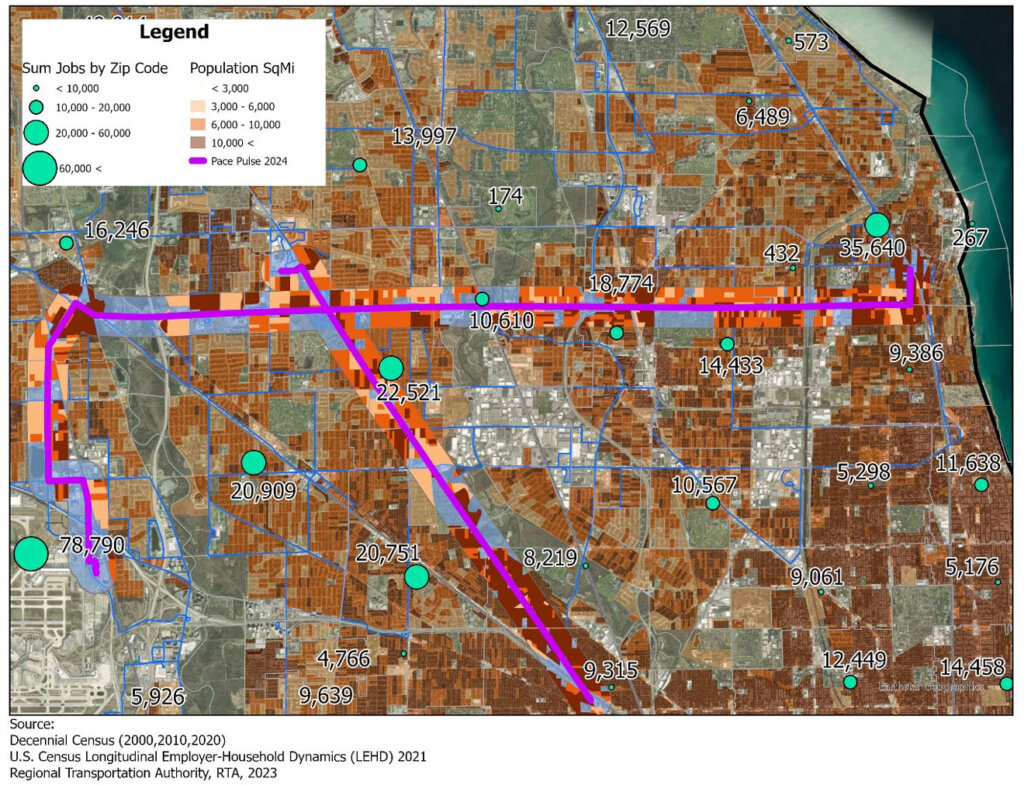
Significant population density is required to run transit service at convenient intervals. According to transit literature, at around 3,000 people per square mile, it makes sense to operate some level of local bus service. At around 10,000 people per square mile frequent transit service becomes feasible. To illustrate, the map below shows the extent of transit-supportive residential densities within 1/4 mile of the two Pace Pulse arterial rapid transit routes in operation along Dempster and Milwaukee.
Transit Supportive Density and Job Density – Pace Pulse

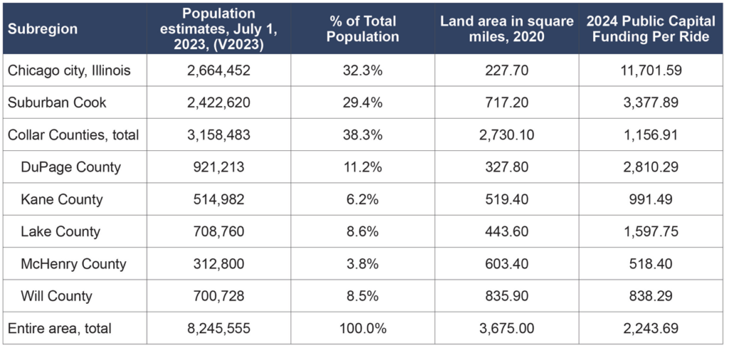
Transit service in low density areas usually costs significantly more than the cost of providing comparable service in high density areas given the longer distances riders travel and the lower numbers of riders paying fares per hour of operation. Thus, it is important to develop densely along current or potential transit corridors, e.g., within a half-mile to one mile of a Metra station or within a quarter to half mile of transit corridors being developed. The table below shows the amount of public subsidy for capital and operations per ride. In lower density areas served by Metra and Pace, where transit covers more distance and carries fewer people, the public subsidy is higher. The table below shows the total operations and capital funding for the service boards divided by ridership, for a subsidy per trip.

Density plays a large role in the amount of people for which transit is a convenient option and thus how many riders are using transit. Average density (population per square mile) varies significantly throughout the region, as shown in the table below as a county average. As of the 2020 Census, an “urban” place must have either at least 5,000 people, or a minimum of 2,000 housing units. McHenry, Kane, and Will counties have large sections that are not designated as urban areas. Parts designated as urban areas have higher densities than what is shown in the table below; the extent of nonurban areas drives down the overall county average.
Population and Density, 2023

Even in generally low-density areas, it is possible to develop useful and cost-effective transit service if the relatively high-density areas along transit corridors are big enough to contain a sufficiently large number of potential transit users. As stated by Jarrett Walker in “The Perils of Average Density”:
Transit reacts mainly with the density right around its stations. It is in the nature of transit to serve an area very unevenly, providing a concentrated value around its stops and stations and less value elsewhere. So what matters for transit is the density right where the transit is, not the aggregate density of the whole urban area.
As shown in the map above, the two Pace Pulse arterial rapid transit corridors in operation have fairly high population density, which makes them candidates for running frequent transit service: 11,869 people per square mile in the Milwaukee Corridor and 11,157 people per square mile in the Dempster corridor. The density of jobs is also an important factor. The estimated number of jobs within ¼ mile of all Pulse corridors is 212,713.
To provide transit access to increasing numbers of people and workers, we should be directing suburban housing and commercial development along these corridors and as well as around Metra stations.
Land use patterns
Beyond raw population density, other land use patterns affect how supportive a community is to transit. The ability to walk to transit stops safely and easily is a key factor in making transit accessible and attractive. Circuitous walking routes, missing sidewalks, and harsh pedestrian environments such as paths and bus stops in close proximity to heavy traffic deter people from using transit. Similarly, when destinations such as schools or shopping are close to each other and situated next to a transit route, transit ridership will be higher than when destinations are far apart and set back from a transit route. (Jarrett Walker, The Transit Ridership Recipe)
The Chicago region wants more and better transit
Despite transportation patterns shifting since the pandemic, transit is still moving more than one million people every day and ridership continues to increase. Chicago Metropolitan Agency for Planning’s Plan of Action for Regional Transit report highlights the region’s vision for transit improvements, including service between suburbs and to a range of destinations not limited to employment locations. Residents want more frequent service for more hours of the day. The need for increased service was a major theme of the transit subject matter hearings held throughout Northeastern Illinois over the summer by the Senate Transportation Committee.
The market is also prioritizing transit and walkability more than ever. Realtor magazine reports in a June 2023 survey that 79% of home buyers strongly prioritize walkable communities and that 65% of respondents say that having public transit nearby is important. Young adults prioritize walkability and proximity to amenities the most.
How do we accelerate density around transit corridors?
As we welcome new residents or employment centers to the region, it is important to guide as much housing and commercial development as possible to transit corridors so that we increase density and make high-quality transit possible.
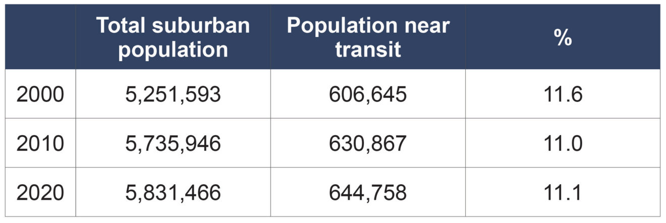
In the past two decades, while the Chicago region added some population near rail transit, the share is less than 20 years ago.
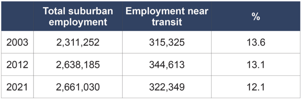
The suburban share of employment near transit likewise has decreased and the number is only slightly higher than it was twenty years ago. CMAP’s long range plan notes that “from 2000-15, the region expanded its developed footprint by nearly 12 percent, an area equal in size to the City of Chicago. Over the same period, employment remained flat, population increased by 4.6 percent, and many opportunities for infill development remained untapped.”
If communities want improved transit, they need to change development patterns to get densities along key corridors that will support high frequency transit.
While a share of Metra riders drive and park at the stations, large swaths of parking are the antithesis of equitable transit-oriented development. Ideally, most people would live and work within walking or biking distance of the station. To support vibrant transit corridors and increase ridership the suburbs need to prioritize infill development near transit.
Suburban population near Metra and CTA rail stations

Suburban employment near Metra and CTA rail stations

Planning for Equitable Transit-Oriented Development
The Chicago region has an opportunity to coordinate transportation and land use planning to encourage density through transit-supportive development around major transit stations and corridors. Communities that want more transit and want to create vibrant areas along these corridors should proactively seek to direct residential and commercial development to locations that are near Metra and CTA stations and along current and future Pace routes. They should review regional transit plans and work to increase density and walkability along those corridors, while being mindful of building and/or preserving affordable housing. Communities like Homewood and Harvey have had success developing and implementing Equitable Transit Oriented Development plans that they shared in a 2022 MPC webinar.
Given that land use and transit service are so connected, the RTA has begun updating its “Transit Friendly Communities Guide” to help community leaders configure future development in a transit-supportive manner. A revised guide will be published by the end of 2024.
Incentives for density
Increased density can be accelerated by communities establishing development incentives like streamlined permitting processes and eliminating parking requirements in transit-oriented development (TOD) areas. RTA recently held a webinar focusing on density and parking policy where Jason Wittenberg, Code Development Manager for the City of Minneapolis, said that dedicating a large portion of land to an inactive use like parking makes residents travel further to desired destinations. Off-street parking increases the space between destinations, making places less walkable and inducing more driving. In Chicago, the Chicago Connected Communities ordinance passed in 2022, allows for reduced parking within ½ mile of a Metra or CTA rail station, and parking mandates are completely eliminated for projects within a TOD area if at least half of the units are assisted or affordable housing. Suburban communities should seriously consider modifying parking mandates so that parking can be “right sized” depending on the development.
CMAP’s role in encouraging density
As the metropolitan planning organization for the Chicago region, CMAP also has a key role to play. CMAP is responsible for planning transportation projects and allocating funding in the region. CMAP currently has the authority to link transportation funding with the provision of transit-supportive land uses.
Under the Illinois Regional Planning Act CMAP’s long range plan must include:
A regional housing component that documents the needs for housing in the region and the extent to which private-sector and public-sector programs are meeting those needs; provides the framework for and facilitates planning for the housing needs of the region, including the need for affordable housing, especially as it relates to the location of such housing proximate to job sites, and develops sound strategies, programs and other actions to address the need for housing choice throughout the region. 70 ILCS 1707/45(i)(1)
The General Assembly has charged CMAP with using incentives as a catalyst to help (and reward) communities that adopt policies that encourage transit-oriented development:
CMAP shall establish an incentive program to enable local governments and developers to: create more affordable workforce housing options near jobs and transit; create jobs near existing affordable workforce housing; create transit-oriented development; integrate transportation and land use planning; provide a range of viable transportation choices in addition to the car; encourage compact and mixed-use development; and support neighborhood revitalization. CMAP shall work with federal, State, regional, and local agencies to identify funding opportunities for these incentives from existing and proposed programs. (70 ILCS 1707/48)
To further the goal of expanding transit-oriented development in the state the Metropolitan Mobility Authority Act, introduced in the General Assembly, would establish a state office of Transit Supportive Development and a fund to be used for incentives. A summary of the legislation is here.
Next Steps
MPC is undertaking research on additional policies needed to advance Equitable Transit Oriented Development throughout the region. We are reviewing current barriers to equitable development near transit at the municipal and regional level and welcome input on technical and policy support needed. If you have suggestions for policies to research or pursue, please contact Audrey Wennink at awennink@metroplanning.org
